All of New Jersey is designated as urban forest. How we allocate and manage our forests and trees depends in large part on how we allocate our land and optimize its use. This section will provide basic information and links about Aberdeen, its subdivisions, parks, wetlands, beaches, trees, flora and fauna, and soil. It will also provide information and links about sustainable landscaping, tree identification and maintenance, soil types, and animal life.
Land use is carefully regulated in New Jersey. The NJ DEP Division of Land Use Regulation has a frequently updated site with links to a roster of pertinent laws and regulations dealing with land development of waterfront, wetlands, tidelands, rivers, creeks, and streams.
Urban Forest Data for New Jersey (produced by the US Forest Service’s Northern Research Station based on national Resource Planning Act (RPA) assessments) says 94.4% of our state’s nearly 8 million residents are classified as urban population. It further asserts that there are 316 square meters of tree canopy per person in the state saving us $191.8 million per year in air pollution costs.
Township Size, Population, Neighborhoods and Parks
Aberdeen Township is 7.8 sq mi (20.1 sq km) in total area, with 5.5 sq mi (71%) of that being land and 2.2 sq mi (29%) water. As of 2010, the population was 18,210, creating a population density of 3,311 persons per square mile.
NEIGHBORHOODS
Aberdeen neighborhoods include: Cliffwood, Cliffwood Beach, Freneau, Oakshades, River Gardens, and Strathmore. These neighborhoods are situated in three different zip codes: 07721 (Cliffwood Post Office), 07735 (Keyport Post Office), and 07747 (Matawan Post Office).
Cliffwood:
The Cliffwood is a neighborhood bounded by County Road, Lenox Road, Whale Creek, and either Cliffwood Avenue or Matawan Avenue.
Heritage Estates includes homes on Stemler Drive and Mystic Court.
Cliffwood Beach:
Cliffwood Beach is a neighborhood bounded by Woodmere Drive, Lakeshore Drive, and Lenox Road; portions of State Route 35, Cliffwood Avenue, and Prospect Avenue; and Whale Creek, Raritan Bay, and Keyport Harbor.
Midnight Point is a small network of homes on and near Lakeshore Drive.
Cinder Hill is in the vicinity of Woodmere Drive and South Concourse.
Freneau:
Freneau is a neighborhood bounded by Texas Road, New Brunswick Avenue (Rte 516), Pemberton Drive (Middlesex County), and Marlboro Township.
Freneau was larger before a referendum in the 1930s resulted in a portion of the neighborhood separating to join Matawan Borough. The Aberdeen portion is no longer contiguous with the rest of the Township.
Jacob E Wilson operated a gristmill on what was then called Henninger’s Mill Road in the 19th century. The road was renamed Wilson Avenue in 1925. (See “Matawan and Aberdeen: Of Town and Field”, by Helen Henderson, pg 29)
Oak Shades:
Oak Shades is a neighborhood bounded by Mohingson Creek, the Garden State Parkway, Lloyd Road, and the Borough of Keyport.
River Gardens:
River Gardens is a neighborhood bounded by Matawan Creek, State Route 35, and either Cliffwood Avenue or Matawan Avenue.
Strathmore:
The Strathmore neighborhood is a large housing development. It is found on both sides of Lloyd Road from the Garden State Parkway to the border with Marlboro Township, and on both sides of Atlantic Avenue from Church Street to State Route 34. It is bounded by Line Road, Van Brackle Road, Gravelly Brook, Church Street, Mohingson Creek, and the NJ Transit North Jersey Coastline tracks.
It was built as a Levitt development in the 1950s and divided into sections identifiable by the common first letter of their street names.
- Andover (A) Section: North of Church Street, west of Lloyd Road, south and east of Line Road. Heather Glen was added in the mid-1990s and is off Line Road at Blair Road. (See 11 Jan 1994 issue of The Asbury Park Press, page 13) Samaha’s Farm is situated at the northern end of the section.
- Bechstein (B) Section: North of Route 34, west of Atlantic Avenue, south of Church Street, and east of Gravelly Brook.
- Cambridge (C) Section: North of Route 34, east of Atlantic Avenue, south of Church Street, and west of Lloyd Road. Courtland and Cypress are major routes.
- Deerfield (D) Section: North of Church Street, west of Lloyd Road, south of the N Section, and east of Mohingson Creek and the Matawan Regional High School.
- Fordham (F) Section: North of Marlboro, west of Lloyd Road, south of the O Section, and east of Gravelly Brook.
- Ivyhill (I) Section: North of Van Brackle, east of Lloyd Road, south of Church Street, and west of Line Road. Ivy Hill Road is a major route.
- Juniper (J) Section: South and east of the I Section along Van Brackle.
- Northland (N) Section: North of the D Section, west of Lloyd Road, south of New Jersey Transit railroad tracks, and east of a dormant section of the Henry Hudson Trail and Mohingson Creek. Santa Fe Junction, originally the Orchards at Aberdeen, was added to the N Section in the mid-1990s. The street names followed the Levitt style, all beginning with the letter N. (See the 11 January 1994 issue of The Asbury Park Press, page 13, for additional information.)
- Oxford (O) Section: North of the F Section, west of Lloyd Road, south of State Route 34, and east of Gravelly Brook and Matawan Borough. (Note that Overbrook and Onyx are in Matawan.)
- Warren (W) Section, aka Storyland: The Woodbrook and Randall Way neighborhoods off Route 34 (Woodbrook Drive and Randall Way, on either side of Avis Rental Cars, are contiguous with the W Section. Wellington Place, Wyndham Place, Heritage Square, and Aspen Woods, also along Route 34, are also reasonably associated with the W Section.
The High School Area
The neighborhood opposite the Matawan Regional High School consists of eight numbered streets between Atlantic Avenue, Lake Boulevard, Little Street and Church Street. The Township often refers to the place simply as the high school area.
For more information on the Township, see the About page on the Township website.
PARKS AND OPEN SPACES
Aberdeen lists fifteen municipal parks:
- Andover Park (Andover Lane, Strathmore) – Basketball court, playground equipment, covered picnic area. (Renovated 2018)
- Cambridge Park (Cambridge Drive, Strathmore) – Playground equipment, swings, basketball court, and baseball field
- Deerfield Park (Deerfield Lane, Strathmore) – Playground equipment, basketball court. (Renovated 2018)
- Fordham Park (Fordham Drive, Strathmore) – Playground equipment, swings, and basketball court.
- Guisti Park (Maxwell Street, Cliffwood) – Football/soccer field, 2 baseball fields, playground equipment, and swings.
- Harrison Park (Harrison Avenue, Oakshades?) – Half basketball court, benches, picnic tables. (Renovated 2018)
- Ivyhill Park (Ivyhill Lane and Idlebrook Lane, Strathmore) – Playground equipment.
- Midland Park (Marjorie Street, Cliffwood) – Playground equipment, basketball court, baseball field, gazebo. (Renovated 2018)
- Northland Park (Northland Lane, Strathmore) – Playground equipment, swings, and a basketball court.
- Oakshades Park (Gerard Avenue, Oakshades) – A lighted softball field, playground equipment, and swings.
- Overlook Park (Prospect at Overlook Circle, Cliffwood Beach) – Playground equipment and swings.
- Alvin Ross Memorial Field (Cliffwood Avenue & Lenox Road, Cliffwood Beach) – 2 softball fields, a soccer field, a basketball court, playground equipment, and swings.
- Storyland Park (Woodman Place, Strathmore) – A softball field, basketball court, and playground equipment.
- Veterans Memorial Park (Ocean Avenue, Cliffwood Beach) – Spray park, climbing equipment, softball field, 2 basketball courts, bathrooms, veterans memorial, gazebo, and a picnic grove with shaded seating. (Renovated 2017)
- Vincent Vinci Park (Gaston Street, Oakshades) – Small garden and a bench. (Dedicated 14 Jul 2012)
You can see these listings at the Aberdeen Parks page on the Township website.
Other parks and open spaces within the Township include the following (updated as of 3 November 2018; see *NOTE below.):
-
- Bechstein Drive has a wooded margin along Route 34 that is Township land. The original Strathmore sales office and model homes were once located here. (29 January 2018)
- Booker’s Bog is a large forest between Cambridge Drive, Cypress Lane, Chilton Lane, Crest Way and the Lloyd Road and Cambridge Drive elementary schools. It is on Aberdeen-Matawan Regional School District property and not part of Cambridge Park or Chilton Park. There are paved walkways between Chilton Lane and the two school properties. According to Free Men Created Community in Matawan, an article by Helen M Starks in the 23 February 1998 edition of The Asbury Park Press, the bog is named for Watson Booker, an African American who owned the land that the school was built on. The article noted that the school is “adjacent to what is still called Booker’s Bogs.” There’s also a rare published reference to the bog in the 26 February 1953 edition of The Matawan Journal, on page 8. A Keyport man was arrested for dumping cesspool sludge on what the police referred to as private property on Lloyd Road in Matawan Township. (30 January 2018)
- Joseph Booket Park is a small recreational park on Wooley Street in the Oakshades neighborhood. It is adjacent to the Oakshades ball fields. There is playground equipment, a swing set, and a basketball court. (7 December 2017)
- Chilton Park is a small park between Cypress Lane and Chilton Lane. It consists of some ornamental trees planted along Cypress Lane, a walkway between the two roads and a small footbridge that crosses Mohingson Creek. It borders Booker’s Bog. (29 January 2018)
- Church Park (identified in the ROSI database) does not exist. It is Township-owned land between Church Street and Cypress Lane. Most of the land is drainage associated with Mohingson Creek. A small part of the land belongs to Chilton Park. (29 January 2018)
- Cliffwood Beach is a public beach between the mouth of Whale Creek and the seawall. A stretch of wooded land along Whale Creek juts out into the bay and is good for bird watching. (29 January 2018)
- Fireman’s Field is the baseball field in Oakshades Park. (29 January 2018)
- Freneau Woods is a Monmouth County Park within the Township. It boasts the headwaters of Matawan Creek and many hiking trails. The park is excellent for bird watching.
- Greenwood Avenue in Cliffwood Beach has Township-owned wooded properties on either side. One side has a stretch of woods that overlooks the wetlands bordering Lakeshore Drive. The other side has woods and wetlands lining a service road that leads to the beach. A stream connecting Whale Creek and Treasure Lake passes under the service road. (29 January 2018)
- Happy Meadows is the extension of Beach Drive in Cliffwood Beach where fall leaves are mulched and stored. The site, also known as Matawan Point, overlooks Keyport harbor. (1 December 2017)
- Hauser Farm is part of what is now known as Freneau Woods, a county park. ( See The Trust for Public Land, which published an article on 4 June 2012 called Hauser Farm Will Become Aberdeen Township Park; the Matawan Patch, which published an article on 14 June 2012 called Aberdeen Purchases Nearly 22 Acres for Passive Recreation Park; the Marlboro Patch, which published an article 24 May 2013 called Monmouth County to Buy 68 Acres for Proposed Marlboro-Aberdeen Park; and The Monmouth Conservation Foundation, which has a paragraph on the Hauser Farm preservation in 2012 on its Property Information page.) (8 December 2017)
- Juniper Park (identified in the ROSI database) is an undeveloped recreational open space in the J Section of the Strathmore neighborhood. The wooded lot is accessible by a path off Jubilee Circle. (This recreational area is mentioned in a 16 January 1980 article in The Matawan Journal, page 1, regarding a proposed water tower.) (18 December 2017)
- The Kavanaugh Trail is a Cheesequake State Park trail that has a trail head on Lakeshore Drive and leads to Whale Creek. It is designated the Red Trail and is not contiguous with the rest of the state park. (29 January 2018)
- Lake Lefferts has recreational facilities along Ravine Drive in Matawan. A small portion of the lake is in the Township. (29 January 2018)
- Lakeshore Drive in Cliffwood Beach has large wetlands on either side associated with Whale Creek tributaries. (29 January 2018)
- The corner of Lenox Road and Lakeshore Drive has a large wooded open space adjacent to Ross Field. The Township purchased the land using Green Acres funds. The space includes some trails and protected wetlands. Access to most of the site is possible but difficult due to heavy brush from points along Lakeshore and Lenox. Access can also be difficult from the pumping station area off Greenwood Avenue due to muddy terrain. The easiest access is from a trail head behind the baseball backstop in Ross Field, but wetlands can pose issues. (4 November 2018)
- Lloyd Park (identified in the ROSI database) does not exist. It is Township-owned property between Lloyd Road and the footbridge at Chilton Park. It is primarily a drainage for Mohingson Creek, although the area along Cypress Lane is part of Chilton Park. (29 January 2018)
- Manzo Field is identified as 140 Lloyd Road, Block 118 Lot 1, 1.1318 acres. It is in the W Section of the Strathmore neighborhood, between Warren Drive and the border with Marlboro Township. The field is mentioned in Parents Want a Field, a 5 June 1996 article in the Independent about the availability of soccer fields. (8 December 2017)
- Oakshades Park has a sign labeling it Fireman’s Field, but locals continue to refer to it as Oakshades Park. Google Maps shows both names. Note that the border with Keyport begins at St Joseph’s ball fields and cemetery. Lloyd Road is called Broadway in Keyport. (1 December 2017)
- Reids Hill Park (identified in the ROSI database) does not exist. It is Township-owned property consisting of a drainage for Mohingson Creek between Lloyd Road and the Iris Way footbridge. (1 December 2017)
- River Gardens Park is a 25-acre undeveloped park or recreational area along Matawan Creek in the River Gardens neighborhood. The land was acquired by the Township in 2004 as open space. The site is good for hiking and birdwatching. It is accessible from a trail head on Riverdale Drive. (3 November 2018)
- Treasure Lake has some Township-owned property adjacent to the seawall, including forest and wetlands. A few small publicly owned land parcels serve as drainage ravines around the lake.
- Whale Creek is likely a reference to Township-owned woodlands, wetlands and drainages along the eastern shore of the creek between State Route 35 and Veterans Park. Cheesequake State Park controls a section of woodlands between the creek and Lakeshore Drive in the Cliffwood Beach section. (29 January 2018)
*NOTE: NJ DEP maintains the Recreational and Open Space Inventory (ROSI), which includes several pages of lot and block descriptions of Green Acres Program-related properties in Aberdeen Township. ROSI hasn’t been updated since 24 June 2014. It includes 13 of the 15 municipal parks listed above (minus Vincent Vinci Park and Oakshades Park) but includes Chilton Park, Church Park, Juniper Park, Lloyd Park, and Reids Hill Park, as well as Fireman’s Field, Manzo Field, Hauser Farm, Happy Meadows, Cliffwood Beach, Whale Creek, Treasure Lake, Lake Lefferts, and properties associated with Matawan Regional High School, Lloyd Road School, and Bechstein Drive. It also includes 54 land units marked as Unnamed.
——————————
The Trust for Public Land (TPL) preserved 15 acres of land near Whale Creek in 2006. The land was a Harbor Estuaries Program priority site. “The property is sandwiched between a town park and state land that borders Whale Creek. The newly protected land will be used for recreation such as hiking and birding and a trail to link Aberdeen’s Alvin Ross Memorial Field to Whale Creek has been discussed. The parcel also provides critical habitat for a variety of plant and bird species, including the threatened black skimmer and endangered least tern. The area is a popular migratory and wintering stopover for songbirds and raptors.” (See Whale Creek Property on Raritan Bay Protected, Trust for Public Lands, 17 March 2006)
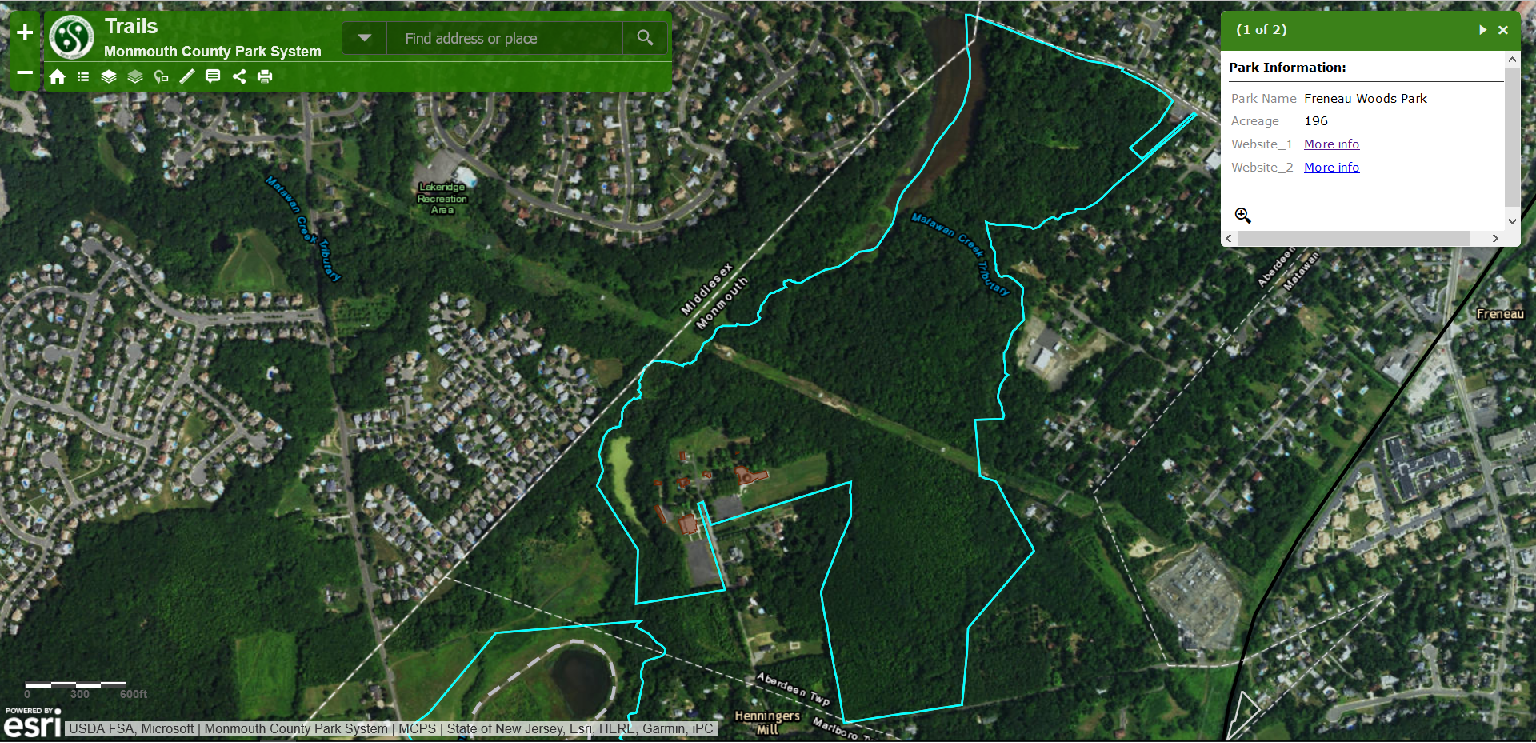 Monmouth County and Aberdeen Township preserved 158 acres of land in the Freneau section of the Township. Freneau Woods is an undeveloped county park off Monastery Lane. (See outlines of Monmouth County parks here.)
The Kavanaugh Trail is a nature trail off Lakeshore Drive in the Cliffwood Beach section of the Township. The land is state owned and is a non-contiguous and mostly undeveloped part of Cheesequake State Park. It leads to vistas on Long Neck Creek and the associated wetlands between Route 35 and the Splash Park at Cliffwood Beach.
The Cliffwood Beach Seawall was erected in the early 1970s between Lakeshore Drive and Beach Drive to defend against an eroding coastline that endangered shoreline houses. Dunes were added to the beach and secured with dune grass, plants, and fencing. Sand was also placed in front of the seawall. A concrete walkway and rail was added to the rocky seawall and was damaged in Superstorm Sandy. “[R]econstruction and extension of the . . . Raritan Bay Seawall Trail began on October 2nd, [2017], starting with demolition of the existing walkway. Completion of the entire reconstruction and extension project is targeted for spring 2018.”
“The new trail, which will run for one-half mile (mostly behind the original seawall itself) will now feature nine fishing outcrops and 15 outlooks with benches for fishermen, joggers and bay-watchers to simultaneously enjoy the scenic area. The project will also add a gazebo on the end of the trail closest to the beach near Lakeshore Drive. A five-foot teak boardwalk will connect the new trail to an outlet path on Lakeshore Drive. A total of 38 LED pathway lights and several security cameras will be added for safety and to help combat vandalism.”
“‘Like Veterans Park, the original Cliffwood Beach Seawall Walk sustained heavy damage during past hurricanes,’ noted Deputy Mayor Margaret Montone. ‘Since the original walkway’s destruction, the township has been seeking approval from the State Department of Environmental Protection to reconstruct an extended trail to post-Sandy standards. Approvals were received in early 2017.'”
‘While the original seawall walk did not connect to the beach, the new Seawall Trail will connect Beach Drive to Lakeshore Drive, creating a unified recreational infrastructure in Cliffwood Beach for the first time in several decades. . . .” (Source: Matawan Patch, 17 October 2017)
Two African-American cemeteries can be found off Reids Hill Road — Union Prospect Cemetery, situated between Lloyd Road and Reids Hill, and Midway Green Cemetery, situated on Reids Hill Road, opposite the other cemetery. (See Pure History for more information about these cemeteries.) According to Free Men Created Community in Matawan, an article by Helen M Starks in the 23 February 1998 edition of The Asbury Park Press, the land for these cemeteries was provided by Watson Booker, an African American resident of the Township.
Sustainable Landscaping
Benefits of Sustainable Landscaping (Adapted from NJ DEP Factsheet)
- Reduces/ prevents pollution and waste disposal; reduces environmental harm;
- Requires fewer inputs (e.g., fertilizers, pesticides) and conserve natural and financial resources;
- Maximizes ecological function and benefit wildlife;
- Requires less maintenance;
- Looks attractive and provides seasonal interest;
- Provides safer environments for our families;
- Provides quieter neighborhoods (from reduced use of power equipment);
- Conserves water for both the homeowner and community;
- Reduces flooding and storm water management costs;
- Creates greater opportunities to enjoy nature;
- Reduces landscape maintenance labor, thereby creating more leisure time;
- Reduces landscape maintenance costs;
- Puts less strain on municipal waste collection and water treatment;
- Provides cleaner water bodies for fishing, swimming, drinking;
- Lowers heating and cooling bills; trees provide can shade and wind breaks, which can reduce building energy needs (up to 30% for home heating [USDOE] and up to 50% for home cooling)
- Reduces noise (buffers)
Shade Tree Resources
- Monmouth County Division of Shade Tree – A county element that maintains trees along county roads, parks and other properties. Website: https://co.monmouth.nj.us/page.aspx?ID=152
- New Jersey Forest Service – A state agency focused on forest and tree management. A subsidiary of New Jersey Department of Environmental Protection (NJ DEP).
- Shade Trees and Community Forestry – Website: http://www.state.nj.us/dep/parksandforests/forest/community/act.html
- Tree Management Tools – NJ DEP provides links to an assortment of tree management tools. Website: http://www.state.nj.us/dep/parksandforests/forest/community/Tree_Tools.html
- Tree Pests and Diseases – NJ DEP provides links related to pests and diseases. Website: http://www.state.nj.us/dep/parksandforests/forest/community/Pests_and_Diseases.htm
- New Jersey Shade Tree Federation (NJSTF) – A non-profit organization that has been assisting those individuals and agencies entrusted with the selection, planting and care of trees, since 1926. Its objective is to educate its members by providing the latest up-to-date information and techniques relating to the care and maintenance of shade trees. Website: http://www.njstf.org/
- New Jersey Forestry Association (NJFA) – Website: http://njforestry.org/about-us/
- United States Forest Service – A national agency managing US forests. Its forest management page has many useful links: https://www.fs.fed.us/forestmanagement/
- Urban Forest Connections Webinar Series – Website: https://www.fs.fed.us/research/urban-webinars/